Walking Tour Guide Sunken Road Maryes Heights Fredericksburg Battlefield


Fredericksburg · Community Photo
Explore the 0.8‑mile Sunken Road Walking Trail, a loop that climbs from the historic stone wall of the Sunken Road up to Marye’s Heights and circles the Fredericksburg National Cemetery. Beginning at the Fredericksburg Battlefield Visitor Center at 1013 Lafayette Boulevard, this self‑guided itinerary leads you past the bullet‑scarred Innis House, the poignant Kirkland Memorial, the artillery crest on Marye’s Heights, and the solemn Superintendent’s Lodge amid more than 15,000 Union burials. Along the way, interpretive markers explain how, on December 13, 1862, Union assaults repeatedly battered the Confederate stone wall, resulting in staggering casualties. Practical details include free parking, open‑daily access from sunrise to sunset, and a leashed‑pet policy on the trail (pets are prohibited inside the cemetery). The walk typically takes 45 to 60 minutes, making it ideal for families, history buffs, and locals seeking a tangible connection to the Civil War while strolling through downtown Fredericksburg. This walking tour guide sunken road maryes heights fredericksburg battlefield offers the most thorough on‑the‑ground perspective, blending tactical history with clear logistics so you can experience the battlefield exactly as it unfolded.
Overview of the Trail
This walking tour guide sunken road maryes heights fredericksburg battlefield invites you to step onto a 0.8‑mile (1.3 km) loop that weaves through the heart of the Fredericksburg Battlefield. Beginning near the Visitor Center, the path follows the historic Sunken Road and climbs to the commanding crest of Marye’s Heights before circling back through the solemn Fredericksburg National Cemetery.
The Sunken Road walking Trail is designed for a comfortable 45‑ to 60‑minute stroll, offering gentle grades that accommodate most walkers while preserving the terrain that shaped one of the Civil War’s fiercest engagements.
On December 13, 1862, Union forces launched wave after wave of assaults against Confederate defenders entrenched behind a stone wall along the Sunken Road. The stubborn defense atop Marye’s Heights forced countless casualties and cemented the battle’s place in American history.
As you move along the route, you will encounter key interpretive stops: the remnants of the original stone wall, the bullet‑scarred Innis House, the Thomas R.R. Cobb Memorial, Kirkland’s Angel monument, the artillery crest on Marye’s Heights, and the Superintendent’s Lodge within the cemetery. Each marker tells a fragment of the story that unfolded on that cold December day.
The grounds are open daily from sunrise to sunset with no entrance fee. Leashed pets may accompany you on the Sunken Road portion, though they are not permitted inside the cemetery. Parking is available at 1013 Lafayette Blvd, making the trail easily reachable for locals and visitors alike.
By walking this loop, you not only experience a scenic Virginia landscape but also walk in the very footsteps of the soldiers who shaped the nation’s past.
Quick Fact | Details |
|---|---|
Trail Distance | 0.8 miles / 1.3 km loop on the Sunken Road walking Trail |
Estimated Time | 45 – 60 minutes |
Terrain & Difficulty | Easy to moderate; packed‑dirt/gravel path with a climb to Marye’s Heights |
Location / Trailhead | Fredericksburg Battlefield Visitor Center, 1013 Lafayette Blvd, Fredericksburg, VA 22401 |
Admission Fee | Free – no entrance fee |
Operating Hours | Grounds open daily sunrise to sunset |
Pet Policy | Leashed dogs allowed along the Sunken Road trail; prohibited inside the Fredericksburg National Cemetery |
Trail Map | Official trail map provided at the Visitor Center |
Battle of Fredericksburg – Sunken Road Fredericksburg
Tactical Dynamics of the Battle
On December 13, 1862, the Battle of Fredericksburg showcased one of the most lopsided assaults of the Civil War. Confederate troops, commanded by General Robert E. Lee, entrenched behind a stone wall that ran the length of the Sunken Road Fredericksburg. The wall, built in the 1830s, provided a low‑lying shield that protected infantry while rifle and artillery fire ripped through any attacker who dared to approach.
Above the road, the Union‑threatened plain was dominated by Marye's Heights. Heavy Confederate artillery was positioned high on the ridge, delivering a relentless barrage that covered the entire approach corridor. Union forces under Major General Ambrose Burnside were forced to leave the cover of the town, cross an exposed half‑mile of open field, and negotiate a narrow canal ditch before even reaching the base of the wall.
Despite the obvious tactical hazards, Burnside ordered wave after wave of Federal soldiers forward. Each charge was met with concentrated fire from the wall’s defenders and the heights’ batteries, halting the Union advance well before the defensive line. The repeated assaults resulted in catastrophic losses, with Union casualties exceeding twelve thousand while Confederate losses remained markedly lower.
Why the Position Was Impregnable
The combination of a sturdy parapet, the natural depression of the sunken road, and the commanding artillery on Marye's Heights created a killing ground that could not be breached. Infantry could shelter behind the wall, reload, and continue firing, while the elevated guns forced attackers to brave a lethal crossfire before even reaching the foot of the obstacle.
Visitors can follow this narrative on the walking tour guide sunken road maryes heights fredericksburg battlefield for a deeper appreciation of the tactical brilliance that turned the Sunken Road into a legend of defensive warfare.
Four Tactical Layers
of the Sunken Road Defense
A self-guided walking tour framework revealing how Confederate defenders combined terrain, architecture, and artillery into one of the Civil War's most formidable positions at Marye's Heights.
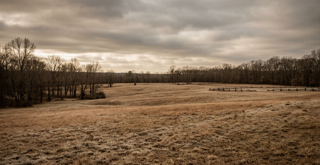
The Open Plain
Roughly 400 to 450 yards of exposed fields, meadows, and fairgrounds that Union troops had to cross under continuous fire. Seven divisions launched fourteen separate, uncoordinated charges here on December 13, 1862—no attacker reached the stone wall.
The Sunken Telegraph Road
A naturally recessed roadway running 3 to 4 feet below the surrounding hill slope—a ready-made trench carved by years of wagon traffic. Confederate brigades, beginning with Gen. Thomas R.R. Cobb's Georgia unit, occupied this low ground with minimal exposure.

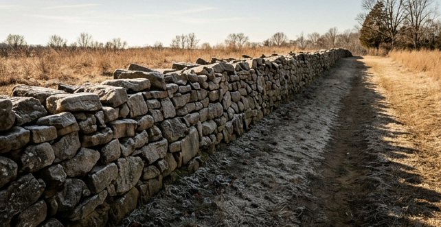
The Stone Wall
A solid stone masonry breastwork extending more than 500 yards along the eastern side of the road. Confederate infantry stood four ranks deep, maintaining a continuous volley as front ranks fired and rear ranks reloaded—earning a reputation as an impregnable barrier.
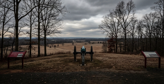
Marye's Heights Artillery
Elevated above the plain, Marye's Heights hosted nine cannons from the Washington Artillery, later reinforced by Col. E.P. Alexander's reserve batteries. From this height, guns delivered enfilading canister and shell fire that swept the open plain below.
Battlefield Trail Guide to Sunken Road Walking Tour Stops
Stop 1 – Entrance & The Historic Stone Wall
Sunken Road walking tour stops begin at the Visitor Center located at 1013 Lafayette Blvd, where the first stop of the historic route welcomes guests. This opening segment introduces the narrative of the Civil War clash that unfolded along a narrow, vegetated trench, guiding walkers toward the dramatic action that shaped the outcome of the Fredericksburg campaign. As you step onto the paved path, interpretive signs describe how Union troops attempted to breach the Confederate line, only to encounter fierce resistance that turned the road into a deadly chute. The atmosphere is enriched by the preserved earthworks and the subtle contours that still echo the sounds of musket fire and artillery. Throughout the walk, you will notice strategic high points that offered commanding views of the battlefield, illustrating why commanders fought so fiercely for this ground. The guide’s commentary emphasizes the significance of Marye’s Heights, linking the terrain to the broader movements of the army. By the time you reach the midpoint, the story has unfolded from the opening assault to the stubborn defense that defined the day. This stop sets the tone for the remaining segments, each of which will reveal additional facets of the engagement, from artillery placements to the retreat of the Union forces. For those seeking a deeper understanding, the experience is complemented by the perspective of a walking tour guide sunken road maryes heights fredericksburg battlefield specialist, ensuring every detail is vividly imagined.
Key Visuals at the Sunken Road
When you join the walking tour guide sunken road maryes heights fredericksburg battlefield experience, the first sensation is the feeling of history beneath your feet. The pathway cuts a deep trench into the base of Marye’s Heights, a natural scar that once directed the thunder of artillery and the disciplined advance of infantry. This sunken roadbone carries the echo of 1862, when Confederate troops organized themselves in four ranks deep, relentless musket fire to sweep the open field above.
Stepping onto the historic sunken roadbed, you notice the stone‑cut ramp that channels you into the very trench where soldiers once stood shoulder to shoulder.
Viewing the preserved sections of stone wall, you can trace the weathered limestone that formed the defensive backbone of the position.
Picturing four rotating Confederate soldiers lining the road, you imagine the rhythm of loading, aiming, and firing that created a continuous barrage.
Each element invites you to visualize the tactical genius of the Confederate infantry, whose depth and discipline turned a simple road into a formidable barrier. The preserved stone wall still stands as a tangible reminder of the engineering that shaped the battle’s outcome, while the road’s depth underscores the strategic advantage gained by occupying lower ground. As you walk the line where history converged, the scene becomes vivid: the clatter of weapons, the smoke of powder, and the steadfast resolve of men fighting for a cause that defined a nation.
Pet‑Friendly Tips for the Sunken Road Trail
If you’re planning a stroll along the Sunken Road Walking Trail, bring your dog on a leash and enjoy the historic landscape together. Leashed pets are welcome throughout the trail, which winds through the Fredericksburg and Spotsylvania National Military Park and offers views of the battlefield’s rolling fields. Once you reach the entrance to the Fredericksburg National Cemetery, however, the rules change: pets are strictly prohibited inside the cemetery grounds. This policy helps preserve the solemn atmosphere and protect the historic monuments.
All park grounds—including the trail and the cemetery—are open daily from sunrise to sunset, so you can schedule your walk to match the light you prefer. Early‑morning visits often provide cooler temperatures and quieter paths, while late‑afternoon walks let you experience the changing shadows over the historic terrain.
When you set out, keep a few practical items on hand: a sturdy leash, waste bags for clean‑up, and a water bottle for both you and your companion. Respect signage along the route, especially where it reminds visitors that the cemetery area is off‑limits to animals. By following these simple guidelines, you’ll help maintain the trail’s natural beauty and ensure that future visitors can also enjoy a pet‑friendly experience.
For those who love detailed history, the trail is a natural extension of any walking tour guide sunken road maryes heights fredericksburg battlefield experience, weaving together the stories of soldiers, civilians, and the landscape that shaped their lives.
Remember: leashed dogs are welcome on the Sunken Road Trail, but must be turned around before crossing into the cemetery. The entire site remains accessible from sunrise until sunset, giving you flexibility to explore at the time that works best for you and your furry friend.
Stop 2 – The Innis House
Welcome to the Innis House, a modest stone structure that quietly watches over the historic Sunken Road trail.
Positioned just a few hundred yards from the low, earth‑cut path that once channeled Union troops, the house offers a perfect pause for those tracing the battle’s movements.
As you step onto the soft dirt beside the house, remember that this spot is one of the Sunken Road walking tour stops that threads together the story of Fredericksburg’s fiercest fighting.
The surrounding meadow still bears the faint rustle of grass that swayed under cannon smoke, and the nearby woods echo the footsteps of soldiers who once slipped through hidden thickets.
Guided by the whispers of history, you can imagine the clatter of artillery as you look toward the scarred embankment where the ground literally swallowed men and horses.
The Innis House itself served as a field hospital for a brief period, its modest rooms hurriedly transformed into recovery bays for the wounded.
Though the original furnishings have long since vanished, the lingering atmosphere conveys the urgency and compassion that defined those makeshift infirmaries.
Take a moment to breathe the crisp autumn air that still carries the faint scent of pine.
Notice the subtle rise of the terrain behind you, a reminder that the Sunken Road was not merely a trench but a strategic corridor that shaped the battle’s outcome.
Whether you are a seasoned historian or a casual visitor, this stop invites you to pause, reflect, and picture the courage that unfolded on these very grounds.
Continue onward along the trail, where each subsequent marker will deepen your understanding of the conflict that forever altered Fredericksburg.
Innis House Highlights
Visitors following a walking tour guide sunken road maryes heights fredericksburg battlefield will find this structure a vivid reminder of Civil War combat.
The 1969 acquisition allowed the National Park Service to protect the house from commercial development. Over the following decade, experts stabilized the foundation, repaired roof timbers, and removed later 20th‑century wallpaper. By 1987, meticulous paint analysis guided a finish that mirrored the 1862 military occupation, giving visitors an authentic visual context.
Frontline Homestead Role: Situated directly on the Sunken Road, the house endured continuous artillery and rifle fire. Bullet‑hole evidence across interior and exterior walls testifies to the ferocity of the 1862 engagement.
Construction Period: Built between 1856 and 1861, the frame reflects mid‑century vernacular architecture common to Fredericksburg’s rural outskirts.
Bullet‑Hole Count: Formal NPS documentation lists 52 perforations, while later researcher surveys record more than 58 individual bullet scars, all preserved after modern layers were removed.
National Park Service Acquisition: The property entered federal stewardship in 1969, joining the Fredericksburg and Spotsylvania National Military Park.
Restoration to 1862 Appearance: Rehabilitation completed in 1987 returned both interior finishes and exterior siding to their wartime condition, allowing interpretation of the house as it stood during the battle.
Historical Residents: John and Ellen Innis lived here in 1861; the land was originally owned by Martha Stephens, whose home lay a short distance to the south.
Today, the Innis House serves as a tactile classroom where scholars and tourists can observe authentic war scars while contemplating the lives of those who took shelter within its walls.
Pet‑Friendly Guidance for Your Fredericksburg Visit
When exploring the historic Sunken Road trail within the Fredericksburg & Spotsylvania National Military Park, keep your canine companion safely leashed. Leashed pets are welcomed on the trail, allowing you to enjoy the scenery and interpretive signs together. However, the adjacent Fredericksburg National Cemetery strictly prohibits pets, so be prepared to leave your dog at the trailhead or find a secure spot before entering the cemetery grounds.
The entire park—covering the Sunken Road trail and the surrounding fields—remains open daily from sunrise to sunset. There is no entrance fee or special permit required, so you can arrive at any time during daylight hours and begin your walk without worrying about cost.
For a deeper historical context, consider following a walking tour guide sunken road maryes heights fredericksburg battlefield narrative, which highlights the tactical significance of the Sunken Road during the Civil War and points out nearby landmarks such as the cemetery. This approach helps you appreciate both the natural beauty and the profound legacy of the battlefield.
Remember to bring water for yourself and your pet, and to respect all posted signage. By adhering to the leashing rule on the trail and avoiding the cemetery area, you’ll ensure a pleasant experience for fellow visitors and maintain the preservation standards set by the National Park Service.
Stop 3 – Kirkland Memorial & Cobb Memorial
Kirkland Memorial – A Sunken Road Walking Tour Stop
Sunken Road Highlights
Walking the Sunken Road, the walking tour guide sunken road maryes heights fredericksburg battlefield reveals layered history at this crucial stop.
Kirkland Memorial: This bronze sculpture rests on a granite pedestal near the crest of the Sunken Road, honoring Sergeant Richard Kirkland, famously called “The Angel of Marye’s Heights.” During the June 1862 battle, Kirkland slipped through Confederate lines to fetch water for Union soldiers whose wounds left them thirsty and dying. His act of compassion became a legend of humanity amid the carnage, and the memorial captures that spirit with a solemn figure holding a water jug. Visitors can view the dedication plaque and reflect on the quiet heroism that inspired countless stories of the Fredericksburg campaign.
Thomas R.R. Cobb Memorial: Located along the Sunken Road, this stone monument marks the exact spot where Confederate Brigadier General Thomas R.R. Cobb fell after being struck by Union fire. His family commissioned the stone, arranging its placement to preserve his memory for future generations. The monument bears his name and a simple inscription, and it was dedicated in 1888. Today, the site serves as a somber reminder of the high cost of the conflict and invites contemplation of the personal sacrifices made by leaders on both sides of the Fredericksburg battle.
Both monuments stand as touchstones for anyone traveling this historic corridor, offering a chance to pause, read the inscriptions, and imagine the moments that shaped the outcome of the Fredericksburg engagement. Their presence reinforces the layered narrative of courage, loss, and reconciliation that defines the Sunken Road today.
Practical Tips for Visiting the Sunken Road Trail
When you set out on the Sunken Road Walking Trail, you can bring a dog or other pet, but it must be on a leash at all times. This policy applies only to the trail itself; the adjacent Fredericksburg National Cemetery does not allow any pets, so keep your companion away from the cemetery grounds. The park’s open hours run from sunrise to sunset each day, providing ample daylight for a relaxed stroll without the need to check specific clock times. Because there are no entrance fees or permits required, you can explore the historic landscape without spending money on admission. Along the route you will pass notable spots such as Marye’s Heights and the Fredericksburg Battlefield Visitor Center, offering opportunities to pause and read interpretive signs that describe the 1862 battles. If you prefer a guided experience, you can follow a walking tour guide sunken road maryes heights fredericksburg battlefield that highlights key viewpoints and explains the tactical significance of the terrain. Remember to bring water for both you and your pet, and to pack out any waste to keep the area clean for future visitors. By respecting the pet restrictions at the cemetery and staying within the daylight window, your visit will be both enjoyable and compliant with park regulations.
Stop 4 – Ascending Marye’s Heights & Artillery Crest
Having explored the opening scenes of the Sunken Road walking tour stops, you now approach the final leg of the journey, a gentle climb that leads toward the artillery crest that once dominated the battlefield. The ascent is modest but its significance is great; from this height you can picture the thunder of cannon fire that rolled across the fields in 1862, and you can sense the strategic importance that the Union and Confederate forces fought over for hours. As you rise, the low stone walls of the Sunken Road become a memory, while the open ridge offers a panoramic view of the surrounding woods and the historic road network that still threads the landscape. Along the way, interpretive markers recount the story of the Confederate artillery positioned on the high ground, and they explain how the Union infantry struggled to seize the ridge. The wind often carries a faint echo of distant musketry, a reminder that this terrain witnessed some of the fiercest fighting in the Civil War. When you reach the crest, pause and look back toward the scarred trench below; the contrast between the sun‑lit rise and the shadowed ditch underscores the drama of the encounter. This culminating point also marks the transition to the next segment of the walking tour guide Sunken Road Marye's Heights Fredericksburg battlefield, where you will continue to follow the battle’s unfolding narrative toward the town’s historic streets. Take a moment to absorb the scene, and let the landscape speak to the courage and sacrifice of those who once stood here.
Trail Highlights
For anyone using a walking tour guide sunken road maryes heights fredericksburg battlefield, the segment from the Thomas R.R. Cobb Memorial offers a compact yet rewarding ascent.
The paved trail climbs upward from the Cobb Memorial along the Sunken Road, covering roughly 0.16 miles of gentle rise before reaching the crest of Marye’s Heights.
At the artillery crest, visitors are treated to sweeping panoramic views that encompass downtown Fredericksburg, the historic plain, and the surrounding countryside, making it an ideal spot for photography and reflection.
Finally, the pathway continues onward, ultimately linking to the Fredericksburg National Cemetery situated at the summit, where the quiet rows of Union headstones mark the conclusion of the walk.
Because the distance is short, the climb is accessible to most walkers, and the gradual incline provides a chance to absorb interpretive signage describing the 1862 battle actions.
Interpretive panels near the memorial explain how General Thomas R.R. Cobb was wounded during the fighting, while later markers describe the strategic importance of Marye’s Heights as a defensive position.
From the crest, the vista stretches across the Rappahannock River valley, revealing the battlefield layout as it appeared in December 1862, which helps contextualize the movements of Union and Confederate forces.
Reaching the cemetery at the top, the atmosphere contrasts with the earlier combat scene, offering a reflective end point that honors the thousands of soldiers interred there.
Overall, this segment blends natural scenery, historic interpretation, and solemn remembrance, making it a concise highlight of the Fredericksburg battlefield experience.
Pet-friendly walking and visitation guidelines
When planning a visit to the Fredericksburg and Spotsylvania National Military Park, remember that leashed pets are welcome on the Sunken Road trail. Keep your dog securely on a leash at all times while exploring the historic earthworks and the surrounding landscape. The trail offers a scenic glimpse of the battlefield, and many visitors enjoy strolling with your companions.
Within the Fredericksburg National Cemetery, pets are strictly prohibited to preserve the solemn atmosphere of the burial grounds. Service animals may accompany their handlers, but all other animals must remain outside the cemetery perimeter.
The park grounds are open daily from sunrise to sunset, providing ample daylight for walks, photography, and historical interpretation. There is no admission fee, so entry to the park is free for all guests.
If you are seeking a detailed narrative of the area, consider joining a walking tour guide sunken road maryes heights fredericksburg battlefield experience offered by park volunteers or local historians. Such tours often highlight the strategic significance of the Sunken Road and the surrounding terrain.
Before you arrive, check the current weather and any seasonal restrictions, and remember to bring water for both you and your pet. By following these guidelines, you can enjoy a respectful and enjoyable visit to this historic site.
Parking is available near the visitor center, and a short walk leads to the trailhead for the Sunken Road. Signage throughout the park helps you stay on designated paths and ensures that both wildlife and historical features are protected.
Essential Walking Advice for the Sunken Road Walking Trail
Before you set out on the 0.8‑mile loop, remember that this is a historic battlefield trail guide. Staying on the established paths preserves the integrity of the stone wall and earthworks that witnessed the December 13, 1862, fighting. Straying off the marked route can damage fragile features, so please remain on the designated trail at all times.
Climbing or leaning on the original stone wall remnants is prohibited. The park’s preservation rules explicitly forbid any contact with these delicate structures, ensuring they endure for future generations to study and reflect upon.
Summer heat can be intense, and there are no water sources along the walk. Bring plenty of drinking water, and avoid drinking from any natural streams or ponds you might encounter. Hydration is essential for enjoying the full breadth of the historic sites without discomfort.
The ascent to Marye’s Heights involves a noticeable incline. Wear sturdy footwear—boots or supportive shoes—to handle uneven ground and the hill’s grade safely. Proper shoes also protect the trail from erosion caused by heavy foot traffic.
By following these simple guidelines, you help protect the battlefield while experiencing a rich, self‑guided tour of the Sunken Road and Marye’s Heights.
Fredericksburg National Cemetery, Marye's Heights Cemetery
Fredericksburg National Cemetery
Established in July 1865 by an act of Congress, the cemetery crowns Marye’s Heights in Fredericksburg, Virginia—the very ridge where Union troops endured fierce combat on December 13, 1862. What began as scattered battlefield burials was transformed into a permanent sanctuary under the U.S. Army Quartermaster Department, offering a quiet place for remembrance.
By the Numbers
Total interments: more than 15,000 United States soldiers.
Unknown burials: roughly 80 % to 85 % of those interred are unidentified, representing over 12,000 Union graves.
Land area: approximately 12 acres of historic terrain.
Construction timeline: work started in 1866, completed in 1869, and the site closed to new routine burials in 1945.
Key Memorials
Humphreys Monument
Erected in the late nineteenth century by veterans, the Humphreys Monument honors the sacrifice of General Andrew A. Humphreys’ division, which fought bravely on Marye’s Heights.
Superintendent’s Lodge
Designed by Quartermaster General Montgomery C. Meigs, the historic brick lodge once housed the cemetery superintendent, symbolizing federal stewardship after the war.
Reflection
The rows here are numbered consecutively, placing privates side‑by‑side with the few marked stones that identify known soldiers. The plain white markers for identified men contrast with the simple square blocks that denote the many unknown Union graves, underscoring the profound human cost of the Civil War. Visitors are invited to walk the grounds with respect, feeling the solemn dignity that the landscape imparts.

Fredericksburg Battlefield Visitor Center Sunken Road Parking
Location & ParkingThe Fredericksburg Battlefield Visitor Center at 1013 Lafayette Blvd serves as the trailhead for the Sunken Road and Marye’s Heights walk. On‑site Sunken Road parking is provided free of charge, allowing visitors to unload equipment and set out directly onto the historic path.
Hours & Admission
The site follows the battlefield walking trail hours of sunrise to sunset each day, and entry is free—no tickets or permits are required. This open‑access schedule lets you start the walking tour guide sunken road maryes heights fredericksburg battlefield experience at any convenient time.
Trail Conditions & Accessibility
The loop measures roughly 0.8 mile and is composed of gravel and packed earth. The Sunken Road segment remains relatively flat, while the ascent to Marye’s Heights presents a gentle‑to‑moderate grade that is manageable for most walkers. A printed Fredericksburg VA walking tour map is available at the visitor center to help navigate each landmark.
Pet Policy
Leashed dogs are welcomed on the outdoor battlefield grounds and along the Sunken Road trail. Pets, however, are not permitted inside the Fredericksburg National Cemetery to preserve the solemn atmosphere of the burial site.
Explore Downtown Fredericksburg
After completing the historic walk, you are only minutes away from downtown Fredericksburg’s vibrant scene. Stroll along Caroline Street or William Street to discover local restaurants, bakeries, craft breweries, and unique shops that showcase the community’s flavor and hospitality.
Discover Downtown Fredericksburg and the Historic Battlefield
Caroline Street has earned the title “Best Main Street in the South” by Garden & Gun (April 2026). The 40‑block National Historic District shelters more than 350 original 18th‑ and 19th‑century buildings and hosts over 100 local shops, boutiques, and chef‑owned restaurants. Highlights you can pop into include the Fredericksburg Visitor Center at 601 Caroline St (phone 540‑373‑1776), Goolrick’s Pharmacy, Art First Gallery (824 Caroline St), VA Diamonds (717 Caroline St), The Card Cellar (915 Caroline St), Riverby Books (805 Caroline St) and Flykup (810 Caroline St).
Pair a downtown stroll with a step‑by‑step walk through the Fredericksburg Battlefield. The Sunken Road Walking Trail is a 0.8‑mile (45‑60 minute) loop that climbs to Marye’s Heights and the Fredericksburg National Cemetery. The grounds are open daily from sunrise to sunset, free of charge, and pets on leashes are welcome on the trail but not inside the cemetery. Parking is available at the Visitor Center, 1013 Lafayette Blvd. The official walking tour guide sunken road maryes heights fredericksburg battlefield points out the stone‑wall remnants, the bullet‑scarred Innis House, the Kirkland Monument (“The Angel of Marye’s Heights”), and other key markers. A printable Fredericksburg VA walking tour map makes navigation easy.
Support local merchants and stay informed by signing up for the official tourism newsletter Xtra. It delivers updates on neighborhood events, historic walking tours, and downtown specials straight to your inbox.
Sunken Road Walking Trail FAQ for Fredericksburg Battlefield
The Sunken Road walking trail FAQ notes that the main loop covers roughly 0.8 miles (1.3 km). Most visitors spend between 45 minutes and an hour strolling the path, pausing at interpretive markers, and visiting the Fredericksburg National Cemetery at the top of Marye's Heights.
Access to the Fredericksburg Battlefield tours, the Sunken Road walking trail, and the adjacent cemetery is completely free. No admission pass or ticket is required, allowing anyone to explore the historic terrain without a cost barrier.
Leashed pets are welcomed on the outdoor battlefield trails that follow the Sunken Road. They must remain on a leash at all times, and animals are not allowed inside the Fredericksburg National Cemetery gates, although service animals are an exception.
The lower portion of the trail features a relatively level, packed‑gravel surface that accommodates sturdy strollers. Ascending Marye's Heights involves inclines and natural terrain, which can be challenging for standard wheelchairs, so visitors should plan accordingly.
The Angel of Marye's Heights was Sergeant Richard Rowland Kirkland of the 2nd South Carolina Infantry. On December 14, 1862, he climbed the stone wall at Marye’s Heights to bring water and warm coats to wounded Union soldiers stranded in the battlefield.